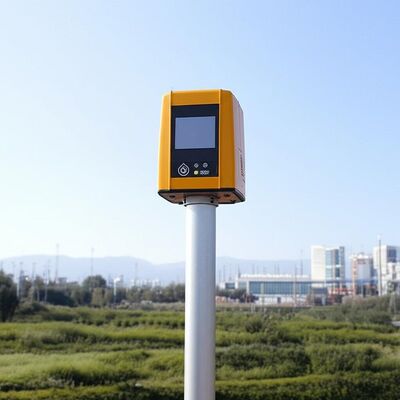
Ürün Tanımı:
Molas 3D, üç boyutlu tarama teknolojisi kullanan gelişmiş bir Doppler rüzgar ölçüm lidarıdır.Rüzgar hızı verilerini doğru bir şekilde yakalamak için pulslu lazer tutarlı Doppler frekans kayması ilkesini kullanır.
Bu yenilikçi cihaz, P-Pl, RHI, DBS ve program taraması da dahil olmak üzere birden fazla tarama modunu destekler.Bu çok yönlülük, çeşitli uygulamalarda belirli rüzgar hızı ölçüm gereksinimlerine uyarlanmasını sağlar..
Molas 3D LIDAR, geniş bir yelpazede özel senaryolar için uygundur. Bunlar arasında deniz rüzgarı kaynaklarının değerlendirilmesi, karmaşık arazilerde araştırma, rüzgar türbini izini tespit,ve havaalanı kaydırma yolunda rüzgar kesimi uyarılarıEk olarak, kentsel meteorolojik gözlemler ve yüksek irtifada türbülans tespiti için de değerlidir.
Özellikleri:
Kapsamlı ölçüm yetenekleri
Sistem, ince bir 3 boyutlu rüzgar alanı ölçüm tekniği kullanarak ayrıntılı ölçüm bilgileri sunar.Bilgilerin doğru ve özel olarak toplanmasına olanak tanıyor.
Geniş algılama aralığı
Geniş algılama aralığı ile donatılmış olan cihaz, özellikle 600 metreden aşağı yüksekliklerde etkili olan 10 kilometreye kadar görüş mesafelerini izleyebilir.
Yüksek Doğruluk Performansı
Bu teknoloji, 0.005 derecelik bir işaret doğruluğu ve saniyede 0.1 metrelik bir rüzgar hızı doğruluğu ile olağanüstü bir hassasiyeti sağlar.
Çeşitli Tarama Yöntemleri
PPl, RHl, DBS ve programlanabilir keyfi tarama yöntemi de dahil olmak üzere birden fazla tarama tekniği desteklenir ve değişen ölçüm ihtiyaçlarına göre çok yönlü çalışma modlarına izin verir.
Esnek ve Hafif Görev
Küçük ve hafif olması için tasarlanan sistem, farklı ortamlarda kolay taşıma ve hızlı dağıtımı kolaylaştırır.
Her Hava Koşulunda Kalıcı
Sert dış ortamlara dayanacak şekilde inşa edilmiş, LPz0'da hayatta kalma kabiliyeti sunar ve hava koşullarından bağımsız olarak güvenilir bir işleyişi sağlayan yıldırım koruma bölgelerine sahiptir.
Güvenlik ve Güvenlik Özellikleri
Güvenlik, entegre GPS konum raporlama ve jeo-çitleme yetenekleri ile çok önemlidir. Ek olarak, veri şifreleme, bilgi sızdırma riskine karşı koruma sağlar.
Çoklu Yapılandırma Seçenekleri
Kullanıcılar, sistemin işleyişini özel gereksinimlere göre uyarlama esnekliği sağlayan dört mesafe çözünürlüğü ve beş birikme süresi arasından seçebilirler.
Teknik parametreler:
| Dikey Aralık |
-10~190° |
| Görme algılama mesafesi |
10 km |
| Rüzgar Hız aralığı |
-75~+75 m/s |
| Uzaklık Çözümü |
15 m / 30 m / 75 m / 120 m |
| Görme Rüzgar Hızı Doğruluğu |
0.1 m/s |
| Uzaklık Katmanları |
300'e kadar |
| Hedefleme Doğruluğu |
±0,005° |
| Toplama Zamanı |
0.2 ~ 10 s (Farklı) |
| Veri Depolama Zamanı |
5 ila 18 ay |
| Dikey ölçüm mesafesi |
4 km |
Uygulamalar:
Rüzgar kaynaklarının değerlendirilmesi, geniş alanlardaki rüzgar alanı verilerinin toplanmasını içerir ve bu da rüzgar enerjisi projeleri için alan seçimiyle ilişkili riskleri en aza indirmeye yardımcı olur.Rüzgar parametrelerini doğru ölçerek, rüzgar kaynaklarının daha iyi planlanmasını ve kullanılmasını sağlar.
Uzak mesafeli güç eğrisi ölçümleri ve dalgalı akım değerlendirmeleri rüzgar enerjisinin kullanımının optimize edilmesinde önemli bir rol oynar.Bu ölçümler, rüzgar akışı dinamikleri ve türbin performansları hakkında ayrıntılı bilgiler sağlayarak rüzgar enerjisi ünitelerinin verimliliğini artırmaya katkıda bulunur..
Rüzgar kesimi ve mikro patlamalar gibi tehlikeli meteorolojik olayları tanımlamak için erken algılama ve uyarı sistemleri gereklidir.Zamanında uyarılar havacılıkta ve diğer hava durumlarına karşı hassas operasyonlarda güvenlik önlemlerini artırabilir.
Havaalanlarında uçuş ayrımını optimize etmek için gerginlik girdabını ölçmek çok önemlidir.Böylece havaalanı trafiğinin verimliliğini ve güvenliğini artırmak.
Rüzgar alanı bilgisi, rüzgarın atmosfersel sınır katmanı içindeki davranışını anlamak için ayrıntılı yardım sağlar.Bu veriler meteorolojik çalışmalar için ve hava tahmin modelleri geliştirmek için hayati önem taşır.
Yüzeyin yakınında, birkaç kilometre içinde, doğru ve yüksek uzay-zaman rüzgar profilleri ölçümleri, düşük irtifalarda gözlem boşluklarını doldurmaya yardımcı olur.Bu gelişmiş veri çözünürlüğü, çevresel izlemeden yenilenebilir enerji geliştirmeye kadar çeşitli uygulamaları destekler..
Rüzgar tüyleri dağılımı hakkında gerçek zamanlı üç boyutlu bilgi, emisyon kaynaklarının etkili bir şekilde takip edilmesini sağlar.Böyle bir izleme özellikle çevre yönetimi ve hava kirliliğinin kontrolü için değerlidir..
Ek olarak, madencilik endüstrisinde toz emisyonunun en iyi şekilde kontrol edilmesi, doğru rüzgar ve dağılım ölçümlerine dayanır.Bu teknikler çevresel etkilerin en aza indirgenmesine ve madencilik faaliyetlerinde operasyonel güvenliğin artırılmasına yardımcı olur.

 Mesajınız 20-3.000 karakter arasında olmalıdır!